Object Record
Images
Metadata
Object Name |
Map |
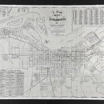
Title |
"A New Map of Louisville" |
Catalog Number |
2004.41.608 |
Creator |
White, W. Lee |
Date |
1856 |
Material(s) |
Paper |
Dimensions |
H-19 W-24 inches |
Description |
This is a map of Louisville and shows the layout of the city on the Ohio River in 1856. The maps title is found in the top center and reads the following, "A New / Map / of / Louisville / ( ( KY. ) ) / Published by W. Lee White. / Reduced from Hart & Mapothers large Map. / Robyn & Co. litho. Louisville, K Hart & Mapothers delt. / Explanation / Find the name of the Street wanted in the list with the initial and figure, then find the corresponding initial in the left of the Map and trace the map until you come under the same figure. / 1856. / Scale 4 inches to a Mile." The list in the top right corner lists the "Louisville Streets" and the list in the Bottom left corner lists the "Reference to Public Buildings. There are two tiny lists in the top left corner that list the "Portland Streets" and the "Shipping Streets." |
Collection |
Martin F. Schmidt Collection |
People |
Hart & Mapother Robyn & Company Schmidt, Martin F. White, W. Lee |
Subjects |
Buildings Cities & towns Lithographs Lithography Maps Prints Streets |
Search Terms |
Louisville (Ky.) Ohio River (Ky.) |
Physical Holder |
Kentucky Historical Society - KHS |