Object Record
Images
Metadata
Object Name |
Map |
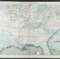
Title |
"Map of the Southern and Border States" |
Catalog Number |
2004.41.611 |
Creator |
Colton, G. Woolworth |
Date |
1862 |
Material(s) |
Paper |
Description |
These are pages 166-167 from Frank Leslie's Pictorial History of the American Civil War that was published in 1862. The pages show a colorful map of the Southern and Border States. This map is entitled, "Map of the Southern and Border States Showing the Actual Positions of the National and Rebel Forces and of the Brocading Fleets and Vessels, the Positions of the Various Fortifications that have been erected, and the localities of all Important Battles that have been fought during the present war." The legend is found in the center below the map and reads "Drawn on Wood / By G. Woolworth Colton N. Y. Scale of Statute Miles." The key is visible just to the right. The tiny maps in the lower right corner show close-ups of "The Southern Position of Florida / on the Same Scale as the Main Map" and the "Vicinity of Washington City D. C." |
Notes |
As mentioned on Martin F. Schmidt's KW 10 note card, "Map of the Southern and Border States, showing the actual positions of the National and Rebel forces, and of the blockading fleets and vessels, the positions of the various fortifications that have been erected, and the localities of all the important battles that have been fought during the present war." |
Collection |
Martin F. Schmidt Collection |
Event |
American Civil War |
People |
Colton, G. Woolworth Leslie's Pictorial History Leslie, Frank |
Subjects |
Battlefields Battlements Battles Borders Civil wars Engraving Engravings Engravings, Wood Forts & fortifications Maps Prints Rebellions Rebels Troop movements War |
Search Terms |
American Civil War Washington (D.C.) |
Physical Holder |
Kentucky Historical Society - KHS |