Object Record
Images
Metadata
Object Name |
Map |
Title |
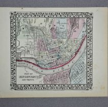
Map, Plan of Cincinnati |
Catalog Number |
2004.41.516 |
Creator |
Mitchell II, S. Augustus |
Date |
1870 |
Material(s) |
Paper |
Dimensions |
H-12.25 W-15.25 inches |
Description |
This is a colored lithograph map entitled the "Plan of Cincinnati and Vicinity." The map depicts the layout of the city of Cincinnati and the neighboring Covington and Newport that are across the Ohio River. The map has been colored in washes of yellow, blue, pink and green. On northern shore of the Ohio River there is a red mark. Surrounding the map there is a winding decorative grapevine. The lower right corner reads "Entered according to Act of Congress in the year 1870 by S. Augustus' Mitchell II in the Clerks Office of the District Court for the Eastern District of Pennsylvania." The lower right corner reads the number "44." |
Notes |
Plan of Cincinnati and Vicinity Includes portions of Covington and Newport, KY |
Collection |
Martin F. Schmidt Collection |
People |
Mitchell II, S. Augustus Schmidt, Martin F. |
Subjects |
Maps Cities & towns Plans |
Search Terms |
Cincinnati (Ohio) Covington (Ky.) Newport (Ky.) Ohio River Pennsylvania Ohio Kentucky |
Physical Holder |
Kentucky Historical Society - KHS |