Object Record
Images
Metadata
Object Name |
Map |
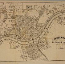
Title |
Map, Cincinnati, Covington & Newport |
Catalog Number |
2004.41.56 |
Creator |
American Photo-Lithographic Company |
Date |
1866 |
Material(s) |
paper |
Dimensions |
H-11 W-14.563 inches |
Description |
This map detailing the Cincinnati, Covington and Newport areas is from "Appleton's Handbook of American Travel", New York, 1867. The Ohio River flows in between the two states. Roads and neighborhoods are labeled. The Licking River comes into the Ohio River from the south. |
Notes |
This map captures the Northern Kentucky area on the eve of significant change. This map was produced in 1866. According to the Encyclopedia of Kentucky, it was the late 1860s and early 1870s when new bridges connecting Northern Kentucky to the Cincinnati area led to major economic expansion and Northern Kentucky becoming part of the Cincinnati metropolitan area. |
Collection |
Martin F. Schmidt Collection |
Subjects |
Lithographs Lithography Maps |
Search Terms |
Ohio River Licking River (Ky.) Cincinnati (Ohio) Ohio Covington (Ky.) Newport (Ky.) Kentucky |
Physical Holder |
Kentucky Historical Society - KHS |