Object Record
Images
Metadata
Object Name |
Map |
Title |
"Sheet C" & "Sheet D" |
Catalog Number |
1984.01.05 |
Date |
1944-1945 |
Material(s) |
Silk/Ink |
Dimensions |
H-28.25 W-28.75 inches |
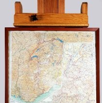
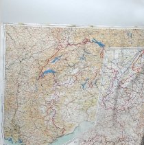
Description |
This is a pair of silk World War II military maps of the central part of Western Europe in one frame. The frame holds one map per side. The backside holds "Sheet C" with the Legend in the upper left corner. The Legend shows the scale to be 1:1,000,000, with distances in miles and kilometers, elevations in feet and meters, and color keys for "Important Through Roads/ Other Main Roads/ Subsidiary Roads/ Special Motorways (Autobahn, etc.)/Numbers of Routes Nationales/tances in Kilometers between black dots or bars/ Railways/ Canals/ International Frontiers/ Former Frontiers/ Holland/ Belgium, (except west coast)/ France,(Northeast)/ Germany, (west and central)/ For enlargement of/ New/ German-Belgian/ Frontier/ see inset Sheet D/turn over." The other side holds "Sheet D", a map of "France/( South East)/ Germany (South West)/ Switzerland/ (Except South East), with an inset on the right of "Belgium & Germany/ (New Frontier)." The Legends are in the lower left corner. |
Collection |
William Buster Collection |
Event |
World War II |
Subjects |
Maps World War II Military occupations Occupied territories Occupations |
Search Terms |
World War, 1939-1945 France European Theatre of Operation Europe Germany Belgium Holland Switzerland Italy |
Physical Holder |
Kentucky Historical Society - KHS |