Object Record
Images

Metadata
Object Name |
Map |
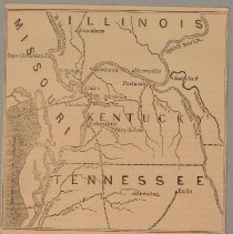
Title |
Magazine illustration, "No. 277, Map of the Country at the Junction of the Miss. and Ohio Rivers" |
Catalog Number |
2004.41.158 |
Creator |
"Leslie's Pictorial History", New York, 1862 |
Date |
1862 |
Material(s) |
Paper/Ink |
Dimensions |
H-5.25 W-4.875 inches |
Description |
This map was printed from a wood engraving and appeared in "Leslie's Pictorial History", New York, 1862. It is captioned "No. 277, Map of the Country at the Junction of the Mississippi and Ohio Rivers" and features the Jackson Purchase area of Kentucky and the adjoining areas of Tennessee, Missouri, and Illinois. |
Notes |
Schmidt catalogue number KW 25, 1825. Removed from Leslie's Pitctorial History, etc., New York, 1862. |
Collection |
Martin F. Schmidt Collection |
Event |
American Civil War |
Subjects |
Maps |
Search Terms |
American Civil War Civil War Civil Wars Mississippi River Ohio River Ohio River Valley |
Physical Holder |
Kentucky Historical Society - KHS |