Object Record
Images


Metadata
Object Name |
Map |
Title |
Post Route Map of the States of Kentucky and Tennessee |
Catalog Number |
2004.41.624 |
Creator |
Nicholson, W.L. |
Date |
1878 |
Material(s) |
Canvas/Paper |
Dimensions |
H-29.375 W-63.5 inches |
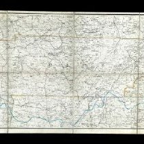
Description |
This is a two part Postal Route Map of Kentucky and Tennessee from 1878. Both maps are eight squares of paper on top of a canvas. They also have a paper cover and on the back and front when folded in a marble pattern. Part A is titled "Upper part of Post Route Map of the States of Kentucky and Tennessee." This section has the title of both maps at the top left corner which reads "Post Route Map of the States of Kentucky and Tennessee with parts of Adjacent States." Below that there is a key and the name of the cartographer and Postmaster General. This part of the map shows Kentucky on the lower half with the southern parts of Illinois, Indiana, and Ohio above it. The western part of West Virginia is at the right side with a small section of Virginia below that. A small section of the eastern side of Missouri is at the left of the map. It has Latitudes and Longitudes on the top and bottom and sides. The borders on the states are in different colors. The map shows the rivers, roads, railroads, cities, towns, and counties of the states shown. There are also lines in blue and pink ink that are the postal routes for several parts of the states. Part B is titled "Lower part of Post Route Map of the States of Kentucky and Tennessee." This part of the map shows the state of Tennessee in the center with the northern parts of Mississippi, Alabama, and Georgia underneath that. The eastern parts of Arkansas and Missouri are on the left side, with the southern part of Kentucky on the top, and the western edges of Virginia and North Carolina at the right. The map also has Latitudes and Longitudes at the top and bottom and sides. The borders of the states are outlined in different colors. The map shows the rivers, roads, railroads, cities, towns, and counties of the parts of the states shown. There are also lines in blue and pink ink that are the postal routes for several parts of the states. |
Collection |
Martin F. Schmidt Collection |
People |
Nicholson, W.L. Schmidt, Martin F. |
Subjects |
Maps Postal service Postal delivery Railroads Rivers Cities & towns |
Search Terms |
Tennessee Postal Service Mississippi River Mississippi Alabama Georgia Kentucky Arkansas Missouri North Carolina Virginia Tennessee River |
Physical Holder |
Kentucky Historical Society - KHS |