Object Record
Images
Metadata
Object Name |
Map |
Catalog Number |
1974.14.06 |
Date |
ca. 1945 |
Material(s) |
Paper/Ink |
Dimensions |
H-14.25 W-20 inches |
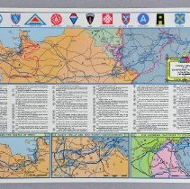
Description |
This is a map of the activities of 6th Armored Division during World War II. The top map is a section of France, Belgium and Germany. The bottom three maps show the following (l to r): "Brittany and the Battle of Brest", "Nancy/Seille and Nied Rivers/Sarreguemines" and "The Ardennes/Bastogne to Sconecken." The text in the center is a description of troop movements. |
Collection |
William Buster Collection |
Event |
World War II |
Subjects |
Maps Battlefields Battles War Troop movements |
Search Terms |
World War, 1939-1945 Belgium France Germany |
Physical Holder |
Kentucky Historical Society - KHS |