Object Record
Images
Metadata
Object Name |
Map |
Title |
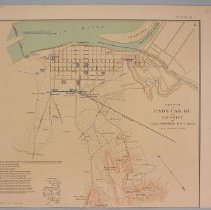
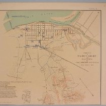
Map, "Paducah, KY. and Vicinity" |
Catalog Number |
2004.41.159 |
Creator |
Rziha, John |
Date |
1954 |
Material(s) |
Paper/Ink |
Dimensions |
H-11 W-12.375 inches |
Description |
This map is a lithograph printed in black, green, blue and red ink and is titled "Paducah, KY. and Vicinity by Captain John Rziha, 19th US Infantry", It is Plate VI, Series 1, Vol. 4, page 339 of an Atlas to accompany the official records of the Union and Confederate Armies. It shows town streets in a grid pattern near the Ohio River, street names, including roads and a railroad line,locations of camps, elevations, and the surrounding countryside. A description of fort armaments is listed in the bottom left corner. |
Notes |
Schmidt catalogue number KW 27, 1827. See also KW 59, 63, 89, 132, 135, 141, 155, 156, 159. From Julius Bien & Co. Lith., New York, 1954, Argosy Book Stores, New York. This map was originally printed in the atlas to accompany the official records of the Union and Confederate Armies. |
Collection |
Martin F. Schmidt Collection |
People |
Rziha, John |
Subjects |
Maps Military camps Military occupations |
Search Terms |
Paducah (Ky.) |
Physical Holder |
Kentucky Historical Society - KHS |