Object Record
Images
Metadata
Object Name |
Map |
Title |
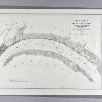
Map, "Ohio River Between Mound City and Cairo" |
Catalog Number |
2004.41.423 |
Date |
1864 |
Material(s) |
Paper |
Dimensions |
H-16 W-24.125 inches |
Description |
This is a survey map where the Ohio River meets the Mississippi River next to two towns form 1864. The map it titled "Ohio River between Mound City and Cairo" and depicts the Ohio River in the middle of the map with Kentucky at the bottom and Illinois at the top. The Mississippi River is at the left of the map and meets the Ohio at the left as well. The shore line on the Kentucky side just shows trees and bushes with a creek at the right called "Cache Chute." The two towns are on the Illinois side with Mound City at the right with the streets drawn out, but with no names. There is a small creek to the left of that city called "Cache R" and then an empty shore line full of trees and bushes. The city of Cairo is at the left of the map in between where the Ohio and Mississippi Rivers meet. It also has the streets drawn out with no names and a long road going above the city. There is print below the title that reads "Surveyed by the Party of F.H. Gerdes.Asst. / Assigned by A.D. Bache, Supdt. / U.S. Coast Survey / to act under orders of / Rear Admiral D.D. Porter. U.S.N., Commanding / Mississippi Squadron. / 1864." |
Notes |
there are no notes for this piece. |
Collection |
Martin F. Schmidt Collection |
People |
Schmidt, Martin F. |
Subjects |
Maps Rivers Cities & towns |
Search Terms |
Ohio River Mississippi River |
Physical Holder |
Kentucky Historical Society - KHS |