Object Record
Images
Metadata
Object Name |
Map |
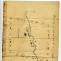
Title |
Survey, Jessamine Creek, for Adam Stephen |
Catalog Number |
UNNUMBERED-289 |
Date |
1774 |
Material(s) |
Paper/Ink |
Dimensions |
H-6.5 W-8.75 inches |
Description |
This is a rectangular scrap of parchment with a hand-drawn land survey of a plot of land around Jessamine Creek "...for Adam Stephen by virtue of the Governor--" The plot of land is on a scale of 100 Poles (16.5ft) to an inch. The surveyor claims that the land has an area of 1000 poles. |
Collection |
KHS Museum Collection |
People |
Stephen, Adam |
Subjects |
Creeks Maps Survey drawings |
Search Terms |
Jessamine Creek Jessamine County (Ky.) |
Physical Holder |
Kentucky Historical Society - KHS |